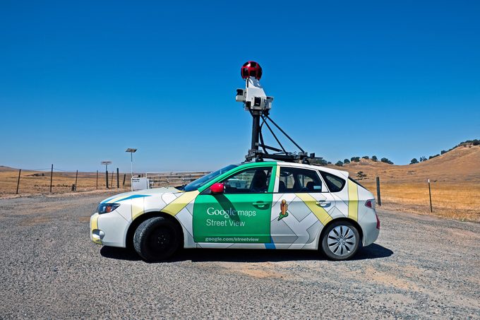
We know you've wondered how Google Street View obtains those eerie pictures of your house

How and When Google Maps Takes Pictures for Street View

Google Street View is handy when you’re checking out an Airbnb, searching for your doctor’s office or moving to a new place and trying to get a lay of the land. Just drop that little gold guy right on the map and “walk” around. But when it’s your house on the internet for everyone to see, it’s a little unnerving. Who took the photo? When does Google Maps take pictures?
They’re fair questions. If you’re wondering how Google Street View gets that picture of your house—or any picture, for that matter—we’ve got answers. Reader’s Digest spoke with Herve Andrieu, aka the Google Street Guru, who has contributed hundreds of thousands of images to Street View. So when does Google Maps take pictures, and who on earth is doing it? Keep reading to learn more.
Get Reader’s Digest’s Read Up newsletter for more tech, humor, travel, cleaning and fun facts all week long.
Who takes Google Street View photos?

Google Street View has two sources of photography: Street View Cars and user-generated content. (Despite what you may have heard, Google is not using satellite technology to get Street View images.) Here’s the breakdown:
Street View cars
The primary way Google Maps gets pictures is with its Street View cars. You’ve probably seen one of these green-and-white or gray vehicles, which are not exactly secretive since they have 360-degree cameras mounted on top.
Street View cars simply drive down the street, taking pictures that will be processed into maps later. These Googlemobiles first debuted in 2007, and they’ve captured more than 10 million miles of streets worldwide from more than 100 countries.
Trekkers
Google also employs backpack-sized cameras called Trekkers, which capture images of narrow streets, alleys, trails and other places cars can’t go. Google Trekkers can be carried or mounted onto motorcycles, snowmobiles and other personal transportation.
Contributor content
Conspicuous camera cars aren’t the only way Google Maps gets Street View images. Anyone can upload 360-degree photos using compatible cameras like GoPros and Insta360s. This is especially helpful in places cars can’t reach or in countries where Google doesn’t send a lot of cars.
“Google heavily relies on the volunteer work from the local guides who are posting pictures day after day,” Andrieu says. “Anyone can be a local guide, as long as they have a Gmail account and access to Google Maps.”
All you have to do is get the right gear, strap the camera to your bike helmet or personal vehicle and start walking, riding or driving. When you’re done, upload your images to Google’s Street View Studio.
When does Google Maps take pictures?
Google Street View cars and cameras are continually upgraded, with new pictures taken every one to three years. (Larger metro areas get updated more often.) The updates happen so frequently, you can often estimate when Google Maps took a picture based on the car in your driveway or whether there’s snow on the ground.
What happens after Google Street View pictures are taken?
Once street-level photos are taken and uploaded, whether by car or user contribution, they get processed and stitched together into the seamless images you see on Street View. The company blurs any faces or license plates that might appear in the images to protect their owners’ safety and privacy.
Is there anywhere they can’t go?
As long as the location is public, then no. (At least in the United States.) That means all-access residential streets are fair game, but gated communities and other restricted areas are not (without special permission, that is).
Of course, other areas of the world have different laws. Andrieu says Germany has pretty strict privacy laws that can prevent Google from publishing pictures of its streets. Other countries and localities will have their own set of rules.
About the expert
|
Why trust us
Reader’s Digest has published hundreds of articles on personal technology, arming readers with the knowledge to protect themselves against cybersecurity threats and internet scams as well as revealing the best tips, tricks and shortcuts for computers, cellphones, apps, texting, social media and more. For this piece on when Google Maps takes pictures, Meghan Jones tapped her experience as a former editor of Reader’s Digest, and then our editors gave it a rigorous review to ensure that all information is accurate and offers the best possible advice to readers. We rely on credentialed experts with personal experience and know-how as well as primary sources including tech companies, professional organizations and academic institutions. We verify all facts and data and revisit them over time to ensure they remain accurate and up to date. Read more about our team, our contributors and our editorial policies.
Sources:
- Herve Andrieu, Google Street View contributor known as the Google Maps Guru
- Google Maps Guru: “About”
- Google Maps: “Discover when, where, and how we collect 360 imagery”
- Redfin: “Google Street View”


